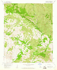
1959 Map of Figueroa Mtn
USGS Topo · Published 1960About this map
The San Rafael Mountains dominate this 1959 landscape, defined by a network of ranching camps and fire lookouts throughout the Los Padres National Forest. Remote outposts like Marre Ranch and Tunnel Ranch are linked by winding jeep trails, while the Figueroa Mtn Lookout and Cachuma Saddle Guard Station mark the era's fire suppression infrastructure. The map reveals the area's geological and human history through diverse place names, from the curious Hells Half Acre to the mining operations at Redrock Mine and Peacock Mine. Large historical land grants are represented by Cañada de los Pinos or College Rancho, showing how private holdings integrated with the surrounding forest and the deep drainages of Lion Canyon and Happy Canyon.
Find a feature on this map
34 named features on this map. Tap any name to fly to it.
Don’t see what you’re looking for? This feature index may not catch every label — zoom into the map to look around manually.
Map Details
Editions of this 1959 Figueroa Mtn Map
4 editions found
Other maps of this area

1902 · Santa Ynez
USGS Topo · 1:125,000

1905 · Santa Ynez
USGS Topo · 1:125,000

1905 · Lompoc
USGS Topo · 1:125,000

1941 · San Rafael Mtn.
USGS Topo · 1:62,500

1941 · McPherson Peak
USGS Topo · 1:62,500

1942 · Lompoc
USGS Topo · 1:125,000

1942 · San Rafael Mtn.
USGS Topo · 1:62,500

1942 · Tepusquet Peak
USGS Topo · 1:62,500

1942 · Los Olivos
USGS Topo · 1:62,500

1943 · San Rafael Mtn.
USGS Topo · 1:62,500