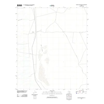
2010 Map of Figure Two Ranch
USGS Topo · Published 2010About this map
Figure Two Ranch sits at the heart of this high-desert landscape in Culberson County, representing the deep-rooted ranching tradition of West Texas. The geography is defined by the stark, expansive Salt Basin, where drainage patterns from the surrounding highlands terminate in mineral-rich flats. This interior drainage system, including runoff from Black John Canyon, creates a unique environmental signature typical of the Trans-Pecos region. Transportation across this arid terrain is facilitated by a network of utilitarian routes such as Stone Rd, Two Flat Rd, and Marvel Rd, which connect remote outposts and grazing lands. The map illustrates a specialized land-use pattern where wide-open spaces are managed through isolated ranching headquarters, dependent on the subtle contours and seasonal water sources of the basin floor.
Find a feature on this map
7 named features on this map. Tap any name to fly to it.
Don’t see what you’re looking for? This feature index may not catch every label — zoom into the map to look around manually.
Map Details
Editions of this 2010 Figure Two Ranch Map
This is the sole edition of this map. No revisions or reprints were ever made.
Other maps of this area

1906 · Van Horn
USGS Topo · 1:125,000

1954 · Van Horn
USGS Topo · 1:250,000

1958 · Van Horn
USGS Topo · 1:250,000

1972 · Square Mesa
USGS Topo · 1:24,000

1973 · Bitter Well Mountain SW
USGS Topo · 1:24,000
1973 · Victorio Peak
USGS Topo · 1:24,000

1973 · Apache Peak
USGS Topo · 1:24,000

1973 · Bitter Well Mountain
USGS Topo · 1:24,000

1973 · Burro Canyon
USGS Topo · 1:24,000
1973 · Seven Heart Gap NW
USGS Topo · 1:24,000