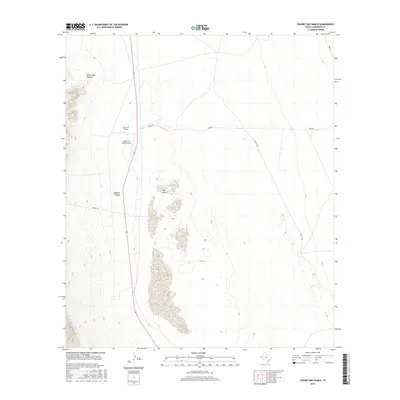
2016 Map of Figure Two Ranch
USGS Topo · Published 2016About this map
Figure Two Ranch sits at the heart of this Culberson County landscape, where the flat expanse of the Salt Basin meets the rising elevations of the west. This 2016 survey illustrates a high-desert environment defined by specialized ranching infrastructure, including the Figure Two Ranch Airport located just south of the main ranch complex. The drainage patterns are clearly marked by the deep incisions of Black John Canyon and Marble Canyon, which cut through the higher ground to the west. A network of rural routes, including Stone Rd, Marvel Rd, and Two Flat Rd, provides the primary access across this sparsely populated region, connecting the central ranching operations to the surrounding terrain.
Find a feature on this map
8 named features on this map. Tap any name to fly to it.
Don’t see what you’re looking for? This feature index may not catch every label — zoom into the map to look around manually.
Map Details
Editions of this 2016 Figure Two Ranch Map
This is the sole edition of this map. No revisions or reprints were ever made.
Other maps of this area

1906 · Van Horn
USGS Topo · 1:125,000

1954 · Van Horn
USGS Topo · 1:250,000

1958 · Van Horn
USGS Topo · 1:250,000

1972 · Square Mesa
USGS Topo · 1:24,000

1973 · Bitter Well Mountain SW
USGS Topo · 1:24,000
1973 · Victorio Peak
USGS Topo · 1:24,000

1973 · Apache Peak
USGS Topo · 1:24,000

1973 · Bitter Well Mountain
USGS Topo · 1:24,000

1973 · Burro Canyon
USGS Topo · 1:24,000
1973 · Seven Heart Gap NW
USGS Topo · 1:24,000