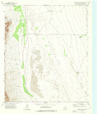
1973 Map of Figure Two Ranch
USGS Topo · Published 1976About this map
Figure Two Ranch stands as the primary namesake for this arid region of West Texas, where the vast Salt Basin (Depression) dominates the landscape. Life in this desert environment is clearly defined by the search for water, evidenced by a network of named water sources including Sal Hepatica Well, Stevens Well, and Dry Bone Well. The topography transitions sharply from the low-lying basin floor to the western elevations cut by Black John Canyon, reflecting the harsh conditions of the Trans-Pecos. Industrial activity is minimal but present, noted by a localized Gravel Pit. The map captures a moment in the early 1970s when these isolated ranching outposts and strategic wells were the essential landmarks for navigation and survival in Culberson County.
Find a feature on this map
12 named features on this map. Tap any name to fly to it.
Don’t see what you’re looking for? This feature index may not catch every label — zoom into the map to look around manually.
Map Details
Editions of this 1973 Figure Two Ranch Map
This is the sole edition of this map. No revisions or reprints were ever made.
Other maps of this area

1906 · Van Horn
USGS Topo · 1:125,000

1954 · Van Horn
USGS Topo · 1:250,000

1958 · Van Horn
USGS Topo · 1:250,000

1972 · Square Mesa
USGS Topo · 1:24,000

1973 · Bitter Well Mountain SW
USGS Topo · 1:24,000
1973 · Victorio Peak
USGS Topo · 1:24,000

1973 · Apache Peak
USGS Topo · 1:24,000

1973 · Bitter Well Mountain
USGS Topo · 1:24,000

1973 · Burro Canyon
USGS Topo · 1:24,000
1973 · Seven Heart Gap NW
USGS Topo · 1:24,000