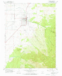
1961 Map of Fillmore
USGS Topo · Published 1978About this map
Fillmore stands as a central hub in the Pavant Valley, appearing here in the early 1960s with its established grid of residential streets and civic landmarks. The map documents the city's historic legacy at the Old State Capitol and the Fairgrounds, alongside educational facilities like Millard High Sch and the Jr High Sch. To the west, the Fillmore Airport and the small settlement of Cessna indicate mid-century aviation and transit growth near the valley floor.
Find a feature on this map
41 named features on this map. Tap any name to fly to it.
Don’t see what you’re looking for? This feature index may not catch every label — zoom into the map to look around manually.
Map Details
Editions of this 1961 Fillmore Map
2 editions found
Other maps of this area

1885 · Beaver
USGS Topo · 1:250,000

1885 · Sevier Desert
USGS Topo · 1:250,000

1953 · Richfield
USGS Topo · 1:250,000

1953 · Delta
USGS Topo · 1:250,000

1958 · Richfield
USGS Topo · 1:250,000

1958 · Delta
USGS Topo · 1:250,000

1960 · Meadow
USGS Topo · 1:24,000

1961 · Fillmore
USGS Topo · 1:24,000

1961 · Mt. Catherine
USGS Topo · 1:24,000

1961 · Richfield
USGS Topo · 1:62,500