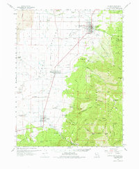
1962 Map of Fillmore
USGS Topo · Published 1975About this map
Fillmore and the surrounding agricultural basin of the Pavant Valley are defined here by a clear transition from volcanic lowlands to high forest peaks. To the west, The Cinders and an extensive area of Lava flow toward Black Rock Volcano, while the eastern horizon rises sharply into the Fishlake National Forest. This 1962 survey documents the essential water infrastructure of the era, from the numerous Wells and Sink features to the high-mountain sources of Chalk Creek and Corn Creek. The map preserves the spatial relationship between established towns like Meadow and Kanosh and the nearby Kanosh Indian Village. Of particular historical interest is the Old Indian Treaty Boundary cutting across the valley floor, alongside traces of industrial activity at the Rock Corral Quarry and various Cinder Pits.
Find a feature on this map
73 named features on this map. Tap any name to fly to it.
Don’t see what you’re looking for? This feature index may not catch every label — zoom into the map to look around manually.
Map Details
Editions of this 1962 Fillmore Map
2 editions found

Other maps of this area

1885 · Beaver
USGS Topo · 1:250,000

1885 · Sevier Desert
USGS Topo · 1:250,000

1932 · Sevier
USGS Topo · 1:62,500

1935 · Sevier
USGS Topo · 1:62,500

1940 · Monroe
USGS Topo · 1:62,500

1944 · Monroe
USGS Topo · 1:62,500

1953 · Richfield
USGS Topo · 1:250,000

1953 · Delta
USGS Topo · 1:250,000

1958 · Richfield
USGS Topo · 1:250,000

1958 · Delta
USGS Topo · 1:250,000