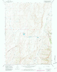
1966 Map of Fillmore Ranch
USGS Topo · Published 1982About this map
Continental Divide winds through this high-elevation landscape, dictating the flow of seasonal waters across Carbon County during the mid-1960s. The remote character of the region is centered on Fillmore Ranch, where man-made infrastructure like a pipeline and small reservoirs at Spillway Elev 7092 and Spillway Elev 7151 supported livestock and water management in a semi-arid environment.
Find a feature on this map
17 named features on this map. Tap any name to fly to it.
Don’t see what you’re looking for? This feature index may not catch every label — zoom into the map to look around manually.
Map Details
Editions of this 1966 Fillmore Ranch Map
2 editions found

Other maps of this area

1932 · Savery
USGS Topo · 1:96,000

1940 · Savery
USGS Topo · 1:125,000

1954 · Rawlins
USGS Topo · 1:250,000

1956 · Bridger Pass
USGS Topo · 1:62,500

1957 · Doty Mountain
USGS Topo · 1:62,500

1958 · Rawlins
USGS Topo · 1:250,000

1961 · Pole Gulch
USGS Topo · 1:24,000

1962 · Rawlins
USGS Topo · 1:250,000

1966 · Creston Junction
USGS Topo · 1:24,000

1966 · Seaverson Reservoir
USGS Topo · 1:24,000