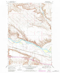
1968 Map of Finch
USGS Topo · Published 1984About this map
Yellowstone River cuts a wide path through the Montana landscape, defining the character of the Howard Valley and the surrounding coulees. In this mid-century environment, agriculture and transportation are intricately linked to the water, evidenced by the extensive irrigation networks of the Hammond Canal and Yellowstone Canal. The settlement at Finch and the nearby Howard Sch provide focal points for the rural community, while the Burlington Northern railroad carries freight along the southern bank. Further south, the landscape is marked by Maudru Spur and the seasonal flows of Reservation Creek. The presence of an Old RR Grade and an Old Railroad Grade north of the river suggests a shift in the local infrastructure as older routes were surpassed by modern rail and road developments.
Find a feature on this map
20 named features on this map. Tap any name to fly to it.
Don’t see what you’re looking for? This feature index may not catch every label — zoom into the map to look around manually.
Map Details
Editions of this 1968 Finch Map
2 editions found
Other maps of this area

1954 · Forsyth
USGS Topo · 1:250,000

1957 · Forsyth
USGS Topo · 1:250,000

1958 · Forsyth
USGS Topo · 1:250,000

1960 · Vananda
USGS Topo · 1:24,000

1960 · Sanders
USGS Topo · 1:24,000

1968 · Donleys Reservoir
USGS Topo · 1:24,000

1968 · Nichols
USGS Topo · 1:24,000

1968 · Finch NE
USGS Topo · 1:24,000

1968 · Finch
USGS Topo · 1:24,000

1971 · Griffin Coulee NE
USGS Topo · 1:24,000