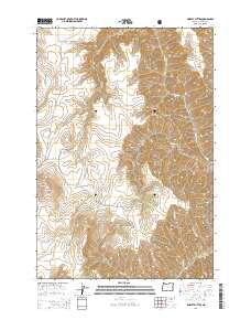
2014 Map of Findley Buttes
USGS Topo · Published 2014About this map
Findley Buttes and the soaring peak of Méexsem Héepey Butte dominate the landscape in this high-altitude corner of Wallowa County. The terrain is defined by a series of significant ridges and deep gulches, including Long Ridge, Imnaha Gulch, and Stickney Gulch, which channel the drainage of numerous small streams. Much of the eastern portion of the map is protected within the Wallowa National Forest, where the topography becomes increasingly complex. Rural infrastructure is sparse, limited to primary access routes like Zumwalt Rd, Johnson Ln, and Trail Creek Rd. These roads skirt the base of hills such as Harsin Butte, following the natural contours of the land carved by Pine Cr and Camp Cr. The arrangement of these roads and watercourses illustrates the traditional land-use patterns of the Oregon high country, where transportation and settlement are dictated by the steep vertical relief and the flow of Butte Cr and Little Sheep Cr.
Find a feature on this map
22 named features on this map. Tap any name to fly to it.
Don’t see what you’re looking for? This feature index may not catch every label — zoom into the map to look around manually.
Map Details
Editions of this 2014 Findley Buttes Map
This is the sole edition of this map. No revisions or reprints were ever made.
Other maps of this area

1954 · Imnaha
USGS Topo · 1:62,500

1954 · Harl Butte
USGS Topo · 1:62,500

1955 · Grangeville
USGS Topo · 1:250,000

1957 · Joseph
USGS Topo · 1:62,500

1957 · Elk Mountain
USGS Topo · 1:62,500

1959 · Grangeville
USGS Topo · 1:250,000

1980 · Grangeville
USGS Topo · 1:100,000

1982 · Wallowa
USGS Topo · 1:100,000

1986 · Enterprise
USGS Topo · 1:100,000

1987 · Riggins
USGS Topo · 1:100,000