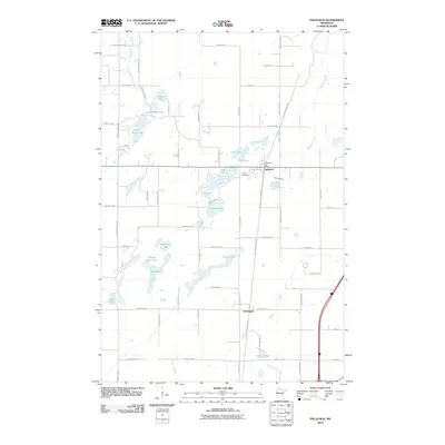
2010 Map of Finlayson
USGS Topo · Published 2010About this map
Finlayson and the smaller settlement of Groningen anchor this Pine County landscape, where the local road network follows a rigid grid interrupted only by a dense concentration of glacial lakes and creek beds. The map shows the Finlayson Post Office and the Finnish Cemetery, reflecting the area's cultural heritage and community center. Water defines the terrain, with the Pine River and Little Pine Creek winding through the western portion, while larger bodies like Indian Lake, Fish Lake, and Clear Lake dot the central plains. Transportation is dominated by north-south corridors like Finlayson Rd and the Willard Munger Trl, which skirts the edge of Skunk Lake as it passes through Groningen. Family names appear on several rural routes and landmarks, including Koski Farm, providing valuable geographic context for local researchers.
Find a feature on this map
68 named features on this map. Tap any name to fly to it.
Don’t see what you’re looking for? This feature index may not catch every label — zoom into the map to look around manually.
Map Details
Editions of this 2010 Finlayson Map
This is the sole edition of this map. No revisions or reprints were ever made.
Other maps of this area

1953 · Duluth
USGS Topo · 1:250,000

1958 · Duluth
USGS Topo · 1:250,000

1961 · Sandstone
USGS Topo · 1:62,500

1961 · Moose Lake
USGS Topo · 1:62,500

1968 · Giese
USGS Topo · 1:24,000
1968 · Kroschel
USGS Topo · 1:24,000

1969 · Arthyde
USGS Topo · 1:24,000

1980 · Sandstone
USGS Topo · 1:100,000

1981 · Willow River
USGS Topo · 1:24,000
1981 · Sandstone North
USGS Topo · 1:24,000