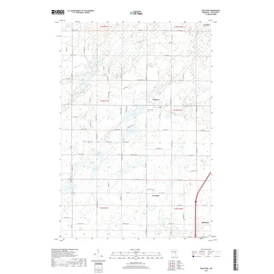
2019 Map of Finlayson
USGS Topo · Published 2019About this map
The town of Finlayson stands as a central hub in this section of Pine County, surrounded by a dense network of glacial lakes and wetlands. The landscape is defined by its water bodies, including the sprawling Fish Lake and Indian Lake, while the Finnish Cem near the town center reflects the cultural heritage of early settlers in the region. To the south, the community of Groningen is situated near the winding Skunk Cr, and a small portion of Sandstone appears at the southeastern edge of the map.
Find a feature on this map
92 named features on this map. Tap any name to fly to it.
Don’t see what you’re looking for? This feature index may not catch every label — zoom into the map to look around manually.
Map Details
Editions of this 2019 Finlayson Map
This is the sole edition of this map. No revisions or reprints were ever made.
Other maps of this area

1953 · Duluth
USGS Topo · 1:250,000

1958 · Duluth
USGS Topo · 1:250,000

1961 · Sandstone
USGS Topo · 1:62,500

1961 · Moose Lake
USGS Topo · 1:62,500

1968 · Giese
USGS Topo · 1:24,000
1968 · Kroschel
USGS Topo · 1:24,000

1969 · Arthyde
USGS Topo · 1:24,000

1980 · Sandstone
USGS Topo · 1:100,000

1981 · Willow River
USGS Topo · 1:24,000
1981 · Sandstone North
USGS Topo · 1:24,000