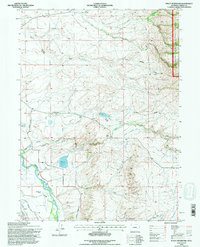
1992 Map of Finley Reservoir
USGS Topo · Published 1996About this map
Finley Ranch and the nearby Finley Reservoir occupy the central high country of this Wyoming landscape, where livestock operations rely on a network of high-altitude drainages and man-made irrigation. The terrain is defined by ranching life, evidenced by named homesteads like the Taylor Ranch, Chistain Ranch, and Blem Ranch. Water management is critical in this environment, shown through the extensive system of ditches including the Want Highland Ditch, Pacific Ditch, and Encampment River Ditch. Along the southern edge, the North Platte River winds near the Lazy River Ranch, marking a significant elevation drop from the higher Buck Ridge to the north. The eastern boundary touches the edge of the Medicine Bow National Forest, where the topography becomes increasingly complex around Cumberland Gulch. Local landmarks such as Fourmile Hill and the Horn and Meason Reservoir highlight the varied uses of the land during the late twentieth century.
Find a feature on this map
37 named features on this map. Tap any name to fly to it.
Don’t see what you’re looking for? This feature index may not catch every label — zoom into the map to look around manually.
Map Details
Editions of this 1992 Finley Reservoir Map
This is the sole edition of this map. No revisions or reprints were ever made.
Other maps of this area

1893 · Fort Steele
USGS Topo · 1:125,000

1939 · Saratoga
USGS Topo · 1:125,000

1954 · Rawlins
USGS Topo · 1:250,000

1955 · Overland
USGS Topo · 1:24,000

1955 · Oberg Ranch
USGS Topo · 1:24,000

1955 · Coad Mountain
USGS Topo · 1:24,000

1958 · Rawlins
USGS Topo · 1:250,000

1961 · Ryan Park
USGS Topo · 1:24,000
1961 · Kennaday Peak
USGS Topo · 1:24,000
1961 · Finley Reservoir
USGS Topo · 1:24,000