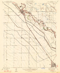
1947 Map of Firebaugh
USGS Topo · Published 1947About this map
The San Joaquin River defines the central axis of this Central Valley landscape, its winding course flanked by an extensive network of irrigation infrastructure and the Southern Pacific railroad line. At the time of this 1946 culture revision, the region’s economy is anchored by the rail corridor connecting Firebaugh and Mendota, where multiple grain or shipping sidings like Cromir and Benito supported local agricultural transport. The map reveals the intricate engineering required for large-scale farming in the San Joaquin Valley, from the elevated Main Canal and Outside Canal to smaller systems like the Lift Canal and No 2 Canal. Named properties such as East Side Ranch and Helm Ranch indicate the transition from early ranching to structured irrigated agriculture, while a dense grid of named avenues like Nees Avenue and Shaw Avenue marks the systematic parceling of the valley floor.
Find a feature on this map
36 named features on this map. Tap any name to fly to it.
Don’t see what you’re looking for? This feature index may not catch every label — zoom into the map to look around manually.
Map Details
Editions of this 1947 Firebaugh Map
2 editions found
Other maps of this area

1913 · Panoche
USGS Topo · 1:125,000

1921 · Mendota
USGS Topo · 1:31,680

1922 · Oxalis
USGS Topo · 1:31,680

1922 · Tufts Ranch
USGS Topo · 1:31,680

1922 · Pozo Farm
USGS Topo · 1:31,680

1922 · Kentucky Well
USGS Topo · 1:31,680

1922 · Chaney Ranch
USGS Topo · 1:31,680

1923 · Wisdom Well
USGS Topo · 1:31,680

1923 · Firebaugh
USGS Topo · 1:31,680

1924 · Tranquillity
USGS Topo · 1:31,680