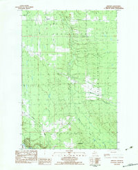
1982 Map of Firesteel
USGS Topo · Published 1983About this map
Firesteel and the surrounding woodlands of the Ottawa National Forest dominate this Upper Peninsula landscape during the early 1980s. The region is defined by an intricate network of waterways, including the winding Flintsteel River and the Rockland River, which carve through the townships of Ontonagon and Greenland. This survey illustrates a landscape of resource extraction and isolated settlement, where logging and transit are evidenced by features like Camp 4 and a series of rural routes such as Firesteel Road and Calumet Road. The presence of a Gravel Pit and a prominent Radio Tower near the center of the sheet highlights the mid-century industrial and communication infrastructure supporting these remote communities. Small tributaries like Monehan Creek and McGuire Creek feed into the larger river systems, illustrating the natural drainage patterns that have historically dictated the placement of roads and homesteads in this part of Michigan.
Find a feature on this map
23 named features on this map. Tap any name to fly to it.
Don’t see what you’re looking for? This feature index may not catch every label — zoom into the map to look around manually.
Map Details
Editions of this 1982 Firesteel Map
This is the sole edition of this map. No revisions or reprints were ever made.
Other maps of this area

1949 · Rockland
USGS Topo · 1:62,500

1950 · Greenland
USGS Topo · 1:62,500

1951 · Rockland
USGS Topo · 1:62,500

1951 · Greenland
USGS Topo · 1:62,500

1955 · Ontonagon
USGS Topo · 1:62,500

1956 · Matchwood
USGS Topo · 1:62,500

1958 · Iron River
USGS Topo · 1:250,000

1960 · Iron River
USGS Topo · 1:250,000

1961 · Iron River
USGS Topo · 1:250,000

1967 · Iron River
USGS Topo · 1:250,000