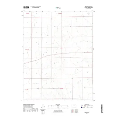
2019 Map of Firstview
USGS Topo · Published 2019About this map
Willow Cr and the upper reaches of Ladder Cr carve subtle drainages through this portion of Cheyenne County, defining the high plains topography of eastern Colorado. The landscape is structured by a rigid grid of rural transport routes, including Co Rd T, Co Rd R, and Co Rd M, which facilitate movement across the agricultural and ranching expanses of the region. This 2019 survey reflects the enduring section-line organization of the American West, where township boundaries like t14s r46w and t15s r46w dictate the layout of modern county infrastructure. The map illustrates how seasonal watercourses like S Ladder Cr are the primary natural landmarks in an otherwise highly engineered landscape of local roads and livestock operations.
Find a feature on this map
16 named features on this map. Tap any name to fly to it.
Don’t see what you’re looking for? This feature index may not catch every label — zoom into the map to look around manually.
Map Details
Editions of this 2019 Firstview Map
This is the sole edition of this map. No revisions or reprints were ever made.
Other maps of this area

1891 · Kit Carson
USGS Topo · 1:125,000

1892 · Cheyenne Wells
USGS Topo · 1:125,000

1893 · Kit Carson
USGS Topo · 1:125,000

1894 · Cheyenne Wells
USGS Topo · 1:125,000

1954 · Lamar
USGS Topo · 1:250,000

1958 · Lamar
USGS Topo · 1:250,000

1981 · Cheyenne Wells
USGS Topo · 1:100,000
1982 · Cheyenne Wells NW
USGS Topo · 1:24,000

1982 · Cheyenne Wells SW
USGS Topo · 1:24,000

1982 · Kit Carson 4 NE
USGS Topo · 1:24,000