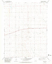
1982 Map of Firstview
USGS Topo · Published 1982About this map
Firstview occupies a high point on the plains of Cheyenne County, serving as a critical junction for the Union Pacific railroad during the early 1980s. The landscape is defined by the ephemeral drainages of Ladder Creek, South Ladder Creek, and Willow Creek, which cut through the high plains terrain. The presence of several Wells and dedicated Storage Bins indicates the agricultural and ranching reliance on groundwater and grain handling in this arid region. Industrial activity is represented by localized Gravel Pits and a prominent Radio Tower, while the settlement at Firstview itself remains a concentrated focal point of activity along the rail line. This survey provides a precise look at the rural infrastructure and water management systems necessary for life in eastern Colorado before the turn of the century.
Find a feature on this map
9 named features on this map. Tap any name to fly to it.
Don’t see what you’re looking for? This feature index may not catch every label — zoom into the map to look around manually.
Map Details
Editions of this 1982 Firstview Map
This is the sole edition of this map. No revisions or reprints were ever made.
Other maps of this area

1891 · Kit Carson
USGS Topo · 1:125,000

1892 · Cheyenne Wells
USGS Topo · 1:125,000

1893 · Kit Carson
USGS Topo · 1:125,000

1894 · Cheyenne Wells
USGS Topo · 1:125,000

1954 · Lamar
USGS Topo · 1:250,000

1958 · Lamar
USGS Topo · 1:250,000

1981 · Cheyenne Wells
USGS Topo · 1:100,000
1982 · Cheyenne Wells NW
USGS Topo · 1:24,000

1982 · Cheyenne Wells SW
USGS Topo · 1:24,000

1982 · Kit Carson 4 NE
USGS Topo · 1:24,000