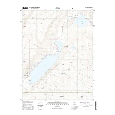
2014 Map of Fish Lake
USGS Topo · Published 2014About this map
Fishlake Resort and Lakeside Resort anchor the western shore of Fish Lake, situated within the expansive high-elevation landscape of the Fishlake National Forest. The topography is defined by the massive Fish Lake Hightop Plateau to the northwest and the Mytoge Mountains rising to the east. This 2014 survey reveals a complex hydrological network where the Fremont River flows near the Johnson Valley Reservoir, while numerous seasonal features like Smith Overflow and Coots Slough mark the lake's southern reaches. Named landmarks such as Elias Wells Hollow and Nampab Swale provide specific points of reference for local historians, tracing the family names and indigenous influences that have shaped this portion of the Sevier and Wayne county line. The presence of State Hwy 25 provides the primary access through this high-country basin.
Find a feature on this map
49 named features on this map. Tap any name to fly to it.
Don’t see what you’re looking for? This feature index may not catch every label — zoom into the map to look around manually.
Map Details
Editions of this 2014 Fish Lake Map
This is the sole edition of this map. No revisions or reprints were ever made.
Other maps of this area

1885 · Fish Lake
USGS Topo · 1:250,000

1896 · Fish Lake
USGS Topo · 1:250,000

1952 · Loa 1 NE
USGS Topo · 1:24,000

1956 · Salina
USGS Topo · 1:250,000

1960 · Salina
USGS Topo · 1:250,000

1962 · Salina
USGS Topo · 1:250,000

1967 · Lyman
USGS Topo · 1:24,000

1968 · Fish Lake
USGS Topo · 1:24,000
1968 · Hilgard Mtn
USGS Topo · 1:24,000
1968 · Boobe Hole Reservoir
USGS Topo · 1:24,000