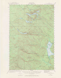
1931 Map of Fish River Lake
USGS Topo · Published 1970About this map
Michauds Mill sits at the northern edge of this remote timber and sporting landscape, where the early 20th-century economy was defined by seasonal camps and logging operations. The intricate network of waterways, including Deboullie Pond, Togue Pond, and the expansive Fish River Lake, served as the primary corridors for movement before the proliferation of modern roads. Evidence of this era's activity is found in the scattered sporting and timber camps such as Red River Camps, Bishops Camps, and Blanchards Depot Camp. Landforms like Black Mountain and Whitman Mtn provided natural landmarks for travelers navigating the tote roads and trails. The map documents a specific phase of Aroostook County's history when the wilderness was managed for its natural resources and sought out for its isolation by hunters and woodsmen.
Find a feature on this map
68 named features on this map. Tap any name to fly to it.
Don’t see what you’re looking for? This feature index may not catch every label — zoom into the map to look around manually.
Map Details
Editions of this 1931 Fish River Lake Map
4 editions found
Other maps of this area

1928 · Eagle Lake
USGS Topo · 1:48,000

1928 · Winterville
USGS Topo · 1:48,000

1930 · Greenlaw
USGS Topo · 1:48,000

1930 · Allagash
USGS Topo · 1:48,000

1930 · St Francis
USGS Topo · 1:48,000

1931 · Fish River Lake
USGS Topo · 1:48,000

1931 · Mooseleuk Lake
USGS Topo · 1:48,000

1931 · Eagle Lake
USGS Topo · 1:62,500

1931 · Winterville
USGS Topo · 1:62,500

1932 · Musquacook Lakes
USGS Topo · 1:48,000