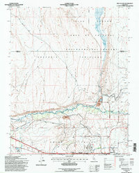
1994 Map of Fish Slough
USGS Topo · Published 1997About this map
Bishop Paiute Indian Res and the northern reaches of Bishop anchor the southern portion of this landscape, where the high desert meets the irrigated agricultural systems of the Owens Valley. The map illustrates a complex network of water management, featuring the North McNally Canal, South McNally Canal, and an Abandoned Canal that trace the historical effort to divert water in this arid region.
Find a feature on this map
31 named features on this map. Tap any name to fly to it.
Don’t see what you’re looking for? This feature index may not catch every label — zoom into the map to look around manually.
Map Details
Editions of this 1994 Fish Slough Map
This is the sole edition of this map. No revisions or reprints were ever made.
Other maps of this area

1912 · Mt. Goddard
USGS Topo · 1:125,000

1913 · Bishop
USGS Topo · 1:125,000

1914 · Mt. Morrison
USGS Topo · 1:125,000

1917 · White Mountain
USGS Topo · 1:125,000

1947 · Mariposa
USGS Topo · 1:250,000

1948 · Mariposa
USGS Topo · 1:250,000

1949 · Mt. Tom
USGS Topo · 1:62,500

1949 · Bishop
USGS Topo · 1:62,500

1951 · Mt. Tom
USGS Topo · 1:62,500

1951 · Bishop
USGS Topo · 1:62,500
Featured Places
- Bishop, CA
- Dixon Lane–Meadow Creek, Dixon Lane-Meadow Creek
- West Bishop, CA
- Brockmans Corner, Dixon Lane-Meadow Creek