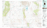
1979 Map of Fish Springs
USGS Topo · Published 1991About this map
The Fish Springs National Wildlife Refuge stands as a vital desert oasis on this 1979 survey, its numerous pools like Curlew Pool and Mallard Pool providing a stark contrast to the surrounding Great Salt Lake Desert. To the north, the expanse of the Dugway Proving Ground occupies a significant portion of the landscape, while the western edge is defined by the high elevations of the Deep Creek Range and Ibapah Peak. The settlement pattern follows the precarious water sources of the Snake Valley, including the small communities of Callao and Partoun, and the historic Boyd Station. Mining activity is scattered across the various ranges, with operations such as the Eagles Nest Mine and Oro del Rey Mine tucked into the canyons. The map effectively captures the intersection of federal military and conservation land use alongside remote agricultural and mining life.
Find a feature on this map
107 named features on this map. Tap any name to fly to it.
Don’t see what you’re looking for? This feature index may not catch every label — zoom into the map to look around manually.
Map Details
Editions of this 1979 Fish Springs Map
4 editions found
Other maps of this area

1885 · Sevier Desert
USGS Topo · 1:250,000

1885 · Tooele Valley
USGS Topo · 1:250,000

1908 · Fish Springs
USGS Topo · 1:250,000

1910 · Fish Springs
USGS Topo · 1:250,000

1925 · Gold Hill
USGS Topo · 1:62,500

1928 · Gold Hill
USGS Topo · 1:62,500

1953 · Dugway Range NE
USGS Topo · 1:24,000

1953 · Dugway Pass
USGS Topo · 1:24,000

1953 · Dugway Range
USGS Topo · 1:62,500

1953 · Topaz Mtn
USGS Topo · 1:62,500