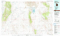
1979 Map of Fish Springs
USGS Topo · Published 1991About this map
Fish Springs National Wildlife Refuge serves as a critical oasis within the arid expanse of the West Desert, featuring a series of managed pools such as Ibis Pool, Mallard Pool, and Pintail Pool. This 1979 survey highlights the isolation of settlements like Callao and Partoun, which are connected by a network of unimproved roads and the Goshute Indian Reservation Trail. The landscape is dominated by north-south mountain ranges, including the Deep Creek Range to the west and the Thomas Range to the east, home to Topaz Mountain. Economic activity is evidenced by numerous mining sites such as the Emma Mine, Utah Mine, and Rainbow Mines, while the northern portion is occupied by the expansive Dugway Proving Ground. The geography illustrates a complex system of internal drainage basins like Snake Valley and Tule Valley that define this part of the Great Basin.
Find a feature on this map
79 named features on this map. Tap any name to fly to it.
Don’t see what you’re looking for? This feature index may not catch every label — zoom into the map to look around manually.
Map Details
Editions of this 1979 Fish Springs Map
4 editions found
Other maps of this area

1885 · Sevier Desert
USGS Topo · 1:250,000

1885 · Tooele Valley
USGS Topo · 1:250,000

1908 · Fish Springs
USGS Topo · 1:250,000

1910 · Fish Springs
USGS Topo · 1:250,000

1925 · Gold Hill
USGS Topo · 1:62,500

1928 · Gold Hill
USGS Topo · 1:62,500

1953 · Dugway Range NE
USGS Topo · 1:24,000

1953 · Dugway Pass
USGS Topo · 1:24,000

1953 · Dugway Range
USGS Topo · 1:62,500

1953 · Topaz Mtn
USGS Topo · 1:62,500