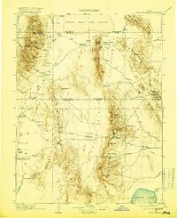
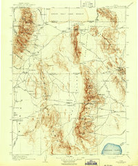
1910 Map of Fish Springs
USGS Topo · Published 1919About this map
The Fish Springs Range and the vast Great Salt Lake Desert dominate this early 20th-century landscape, a region defined by its isolated ranches and scattered mining operations. The map records the human footprint in this arid environment through family-named sites like Meecham's Ranch and Butson's Ranch, alongside the Queen of Sheba Mine and Ibex Mine. These settlements and industrial outposts are connected by early trails and wagon roads such as the route To Pleasant Valley and To Ajax. The presence of Indian Village and Boyd Station reflects the diverse social and logistical history of the West Desert. In the south, the massive shoreline of Sevier Lake marks the terminus of the Sevier River, providing a stark hydrological contrast to the mountain passes like Marjum Pass and the high peaks of the House Range.
Find a feature on this map
89 named features on this map. Tap any name to fly to it.
Don’t see what you’re looking for? This feature index may not catch every label — zoom into the map to look around manually.
Map Details
Editions of this 1910 Fish Springs Map
6 editions found
Other maps of this area

1885 · Beaver
USGS Topo · 1:250,000

1885 · Sevier Desert
USGS Topo · 1:250,000

1885 · Tooele Valley
USGS Topo · 1:250,000

1908 · Fish Springs
USGS Topo · 1:250,000

1910 · Fish Springs
USGS Topo · 1:250,000

1925 · Gold Hill
USGS Topo · 1:62,500

1928 · Gold Hill
USGS Topo · 1:62,500

1949 · Garrison
USGS Topo · 1:62,500

1951 · Garrison
USGS Topo · 1:62,500

1953 · Dugway Range NE
USGS Topo · 1:24,000