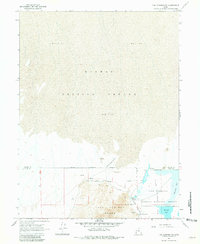
1967 Map of Fish Springs NW
USGS Topo · Published 1981About this map
The Dugway Proving Ground dominates the northern expanse of this landscape, its boundary marking a sharp transition into the wetlands of the Fish Springs National Wildlife Refuge to the south. Historically significant transportation routes intersect this arid terrain, notably the Pony Express Road which skirts the base of the Fish Springs Range. The presence of numerous water sources such as Wilson Health Springs, Deadman Spring, and the North Springs highlights the critical importance of reliable water for travelers and wildlife in the Great Basin. Within the refuge, managed water bodies like Harrison Pool and Pintail Pool indicate a structured approach to conservation. The map also delineates the administrative transition across the Tooele Co Juab Co line, emphasizing the region's isolated yet heavily managed character during the late 1960s.
Find a feature on this map
17 named features on this map. Tap any name to fly to it.
Don’t see what you’re looking for? This feature index may not catch every label — zoom into the map to look around manually.
Map Details
Editions of this 1967 Fish Springs NW Map
2 editions found
Other maps of this area

1908 · Fish Springs
USGS Topo · 1:250,000

1910 · Fish Springs
USGS Topo · 1:250,000

1953 · Tooele
USGS Topo · 1:250,000

1953 · Delta
USGS Topo · 1:250,000

1954 · Granite Peak SE
USGS Topo · 1:24,000

1955 · Tooele
USGS Topo · 1:250,000

1958 · Delta
USGS Topo · 1:250,000

1962 · Delta
USGS Topo · 1:250,000

1967 · Fish Springs NW
USGS Topo · 1:24,000

1967 · Fish Springs SE
USGS Topo · 1:24,000