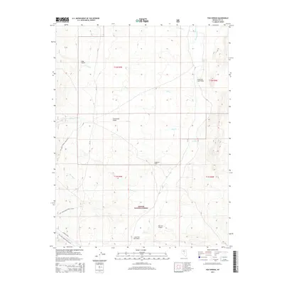
2014 Map of Fish Springs
USGS Topo · Published 2014About this map
Little Fish Lake Valley dominates this high-altitude landscape within the Toiyabe National Forest, where a network of seasonal washes and springs defines the remote Nye County terrain. The presence of Anderson Field in the central basin suggests a history of grazing or limited agricultural use amidst the complex drainage patterns of Tulle Cr, Clear Cr, and Sawmill Cr. Canyons such as Tulle Canyon and Cottonwood Canyon cut through the surrounding uplands, providing natural corridors that have likely guided movement through this portion of the Great Basin for generations.
Find a feature on this map
22 named features on this map. Tap any name to fly to it.
Don’t see what you’re looking for? This feature index may not catch every label — zoom into the map to look around manually.
Map Details
Editions of this 2014 Fish Springs Map
This is the sole edition of this map. No revisions or reprints were ever made.
Other maps of this area

1956 · Tonopah
USGS Topo · 1:250,000

1959 · Tonopah
USGS Topo · 1:250,000

1962 · Tonopah
USGS Topo · 1:250,000

1967 · Upper Fish Lake
USGS Topo · 1:24,000

1967 · Morey Peak
USGS Topo · 1:24,000

1968 · Morey Peak
USGS Topo · 1:62,500

1968 · Fish Springs
USGS Topo · 1:62,500
1968 · Stargo Creek
USGS Topo · 1:24,000
1968 · Fish Springs NE
USGS Topo · 1:24,000
1968 · Fish Springs SE
USGS Topo · 1:24,000