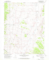
1968 Map of Fish Springs
USGS Topo · Published 1972About this map
Little Fish Lake Valley provides a remote backdrop for this 1968 study, a landscape defined by seasonal watercourses and high-altitude ranching outposts. The map, produced in cooperation with the Atomic Energy Commission, highlights the isolation of settlements like Fish Springs and Clear Creek Ranch situated along the edge of the Toiyabe National Forest. The presence of a Drill Hole and several Jeep Trails suggests a period of active exploration or resource assessment in this corner of Nye County.
Find a feature on this map
20 named features on this map. Tap any name to fly to it.
Don’t see what you’re looking for? This feature index may not catch every label — zoom into the map to look around manually.
Map Details
Editions of this 1968 Fish Springs Map
This is the sole edition of this map. No revisions or reprints were ever made.
Other maps of this area

1956 · Tonopah
USGS Topo · 1:250,000

1959 · Tonopah
USGS Topo · 1:250,000

1962 · Tonopah
USGS Topo · 1:250,000

1967 · Upper Fish Lake
USGS Topo · 1:24,000

1967 · Morey Peak
USGS Topo · 1:24,000

1968 · Morey Peak
USGS Topo · 1:62,500

1968 · Fish Springs
USGS Topo · 1:62,500
1968 · Stargo Creek
USGS Topo · 1:24,000
1968 · Fish Springs NE
USGS Topo · 1:24,000
1968 · Fish Springs SE
USGS Topo · 1:24,000