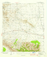
1944 Map of Fisher Hills
USGS Topo · Published 1957About this map
Southern Pacific railroad tracks dominate the central corridor of this Southeastern Arizona landscape, cutting through the critical Railroad Pass between the Graham Mountains and the Dos Cabezas Mountains. This mid-century survey captures a network of high-desert ranching and transit during the Second World War era, punctuated by isolated settlements like Raso, Luzena, and Cholla. The presence of an inactive C O C Camp and several named cattle operations, such as Ten Ranch and the Flying W Ranch, illustrates the transition of land use in the Sulphur Spring Valley and the surrounding foothills of the Crook National Forest. Significant drainage systems like Sycamore Wash and Gold Gulch trace the complex hydrology of the Fisher Hills, while historic highways U.S. 666 and Ariz. 86 parallel the rail line, marking the primary arteries of regional commerce and travel.
Find a feature on this map
37 named features on this map. Tap any name to fly to it.
Don’t see what you’re looking for? This feature index may not catch every label — zoom into the map to look around manually.
Map Details
Editions of this 1944 Fisher Hills Map
3 editions found
Other maps of this area

1917 · San Simon
USGS Topo · 1:125,000

1922 · Willcox
USGS Topo · 1:125,000

1926 · Cochise Head
USGS Topo · 1:62,500

1928 · Bowie
USGS Topo · 1:62,500

1942 · Mt. Graham
USGS Topo · 1:62,500

1943 · Dos Cabezas
USGS Topo · 1:62,500

1943 · Willcox
USGS Topo · 1:62,500

1943 · Cochise
USGS Topo · 1:62,500

1944 · Fisher Hills
USGS Topo · 1:62,500

1945 · Mt. Graham
USGS Topo · 1:62,500