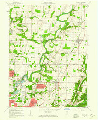
1959 Map of Fishers
USGS Topo · Published 1967About this map
The White River carves a winding path through the heart of Hamilton and Marion counties, anchoring a landscape where early agriculture was rapidly meeting suburban expansion. In the late 1950s, the community of Fishers remained a modest rail stop along the New York Central RR, while Castleton served as a key junction for the Chicago and St Louis RR. The map documents a dense network of family-named landmarks and local institutions, from Weaver Cem in the north to the Broad Ripple Ch further south. The southern edge is defined by the northern reaches of the Fort Benjamin Harrison Mil Res, showing the intersection of military land use with new residential developments like Ivy Hills and Mayflower Meadows. This survey records the area before major highway construction fully transformed these rural townships into the modern suburban corridor.
Find a feature on this map
91 named features on this map. Tap any name to fly to it.
Don’t see what you’re looking for? This feature index may not catch every label — zoom into the map to look around manually.
Map Details
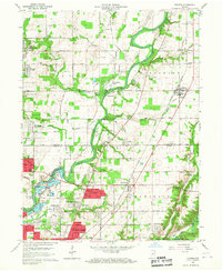
Editions of this 1959 Fishers Map
2 editions found
Other maps of this area

1948 · Indianapolis East
USGS Topo · 1:24,000

1948 · Indianapolis West
USGS Topo · 1:24,000

1952 · Cumberland
USGS Topo · 1:24,000

1952 · Fishers
USGS Topo · 1:24,000

1952 · Carmel
USGS Topo · 1:24,000

1952 · Mc Cordsville
USGS Topo · 1:24,000

1953 · Westfield
USGS Topo · 1:24,000

1953 · Riverwood
USGS Topo · 1:24,000

1953 · Noblesville
USGS Topo · 1:24,000

1953 · Cincinnati
USGS Topo · 1:250,000