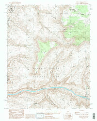
1988 Map of Fishtail Mesa
USGS Topo · Published 1988About this map
Colorado River currents define the southern reaches of this landscape, carving through the Granite Narrows and churning at Fishtail Rapids. The terrain is characterized by massive vertical relief, where the prominent Fishtail Mesa rises above the surrounding canyons and leads to the overlook at Fishtail Point. This 1980s provisional survey by the U.S. Geological Survey documents a wilderness environment shaped by seasonal water and geological landmarks, including the Keyhole Natural Bridge near Hundred and Forty Mile Canyon. The area is largely defined by federal protections, spanning the Grand Canyon National Park and the Kanab Creek Wilderness. Vital water sources for backcountry travelers are noted throughout the arid breaks, such as Indian Hollow Spring, Hualapai Spring, and the dramatic Deer Creek Falls near the river’s edge.
Find a feature on this map
24 named features on this map. Tap any name to fly to it.
Don’t see what you’re looking for? This feature index may not catch every label — zoom into the map to look around manually.
Map Details
Editions of this 1988 Fishtail Mesa Map
2 editions found
Other maps of this area

1886 · Kaibab
USGS Topo · 1:250,000

1953 · Grand Canyon
USGS Topo · 1:250,000

1957 · Grand Canyon
USGS Topo · 1:250,000

1957 · Jumpup Canyon
USGS Topo · 1:62,500

1958 · Grand Canyon
USGS Topo · 1:250,000

1958 · Big Springs
USGS Topo · 1:62,500

1960 · Grand Canyon
USGS Topo · 1:250,000

1962 · Kanab Point
USGS Topo · 1:62,500
1962 · Powell Plateau
USGS Topo · 1:62,500

1984 · Grand Canyon
USGS Topo · 1:100,000