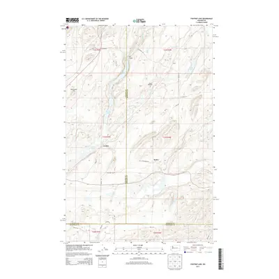
2014 Map of Fishtrap Lake
USGS Topo · Published 2014About this map
Fishtrap Lake and the basalt-carved scablands of Eastern Washington define this landscape, where Lincoln, Spokane, and Whitman counties meet. This 2014 survey captures a rural mosaic of small lakes and seasonal drainages, including Hog Lake and Feustal Lake, situated among the complex topography of the Channeled Scablands. The area is marked by scattered historic settlements like Rodna and Croskey, which emerged along the rail corridors that once bridged the distance between the region's agricultural hubs.
Find a feature on this map
42 named features on this map. Tap any name to fly to it.
Don’t see what you’re looking for? This feature index may not catch every label — zoom into the map to look around manually.
Map Details
Editions of this 2014 Fishtrap Lake Map
This is the sole edition of this map. No revisions or reprints were ever made.
Other maps of this area

1954 · Cheney
USGS Topo · 1:62,500

1954 · Sprague
USGS Topo · 1:62,500

1955 · Spokane
USGS Topo · 1:250,000

1958 · Spokane
USGS Topo · 1:250,000

1964 · Lamont NE
USGS Topo · 1:24,000

1964 · Lamont NW
USGS Topo · 1:24,000

1964 · Rock Lake
USGS Topo · 1:24,000
1980 · Sassin
USGS Topo · 1:24,000
1980 · Lance Hills
USGS Topo · 1:24,000
1980 · Tyler
USGS Topo · 1:24,000