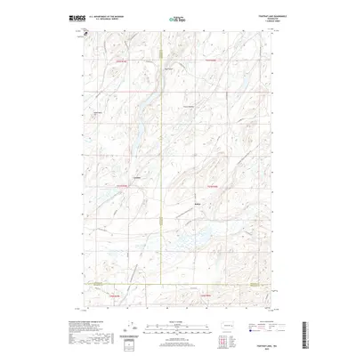
2020 Map of Fishtrap Lake
USGS Topo · Published 2020About this map
Downs Lake and the surrounding wetland complex define this landscape at the intersection of Spokane, Lincoln, and Whitman counties. The terrain is a network of coulees and scablands, where water features like Clear Lake, Stoner Lake, and the long basin of Hog Canyon cut through the basalt-pocked plateau. Transportation in the area is rooted in historical rail corridors, now preserved as the Columbia Plateau State Park Trail, which passes near the settlements of Rodna and Croskey. The drainage pattern is complex, with seasonal and permanent flows such as Negro Cr and Damage Cr moving through the depressions between landmarks like Watermelon Hill. This 2020 survey illustrates how modern recreation and historical homesteading sites, identified by family-named roads like S Falk Rd and W Scroggie Rd, coexist within the sensitive Channeled Scablands environment.
Find a feature on this map
37 named features on this map. Tap any name to fly to it.
Don’t see what you’re looking for? This feature index may not catch every label — zoom into the map to look around manually.
Map Details
Editions of this 2020 Fishtrap Lake Map
This is the sole edition of this map. No revisions or reprints were ever made.
Other maps of this area

1954 · Cheney
USGS Topo · 1:62,500

1954 · Sprague
USGS Topo · 1:62,500

1955 · Spokane
USGS Topo · 1:250,000

1958 · Spokane
USGS Topo · 1:250,000

1964 · Lamont NE
USGS Topo · 1:24,000

1964 · Lamont NW
USGS Topo · 1:24,000

1964 · Rock Lake
USGS Topo · 1:24,000
1980 · Sassin
USGS Topo · 1:24,000
1980 · Lance Hills
USGS Topo · 1:24,000
1980 · Tyler
USGS Topo · 1:24,000