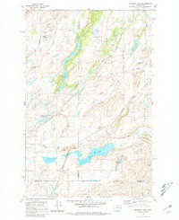
1981 Map of Fishtrap Lake
USGS Topo · Published 1981About this map
Fishtrap Lake and Down's Lake dominate this high-desert plateau landscape, where Lincoln, Spokane, and Whitman counties converge. The mapping reveals a specialized transportation and agriculture corridor defined by the Burlington Northern and Union Pacific railroads. Small rail-side clusters like Rodna and Croskey are visible, alongside infrastructure such as storage bins and several gravel pits, reflecting the area's rural industrial character during the early 1980s. The terrain is marked by distinctive basalt formations and coulees, including Square Butte, Watermelon Hill, and the expansive Owens Meadow. Water is a defining feature of the local geography, with numerous smaller bodies like Hog Lake, Feustal Lake, and Dixons Pond scattered across the scablands, many connected by ephemeral flows like Damage Creek and Negro Creek.
Find a feature on this map
29 named features on this map. Tap any name to fly to it.
Don’t see what you’re looking for? This feature index may not catch every label — zoom into the map to look around manually.
Map Details
Editions of this 1981 Fishtrap Lake Map
This is the sole edition of this map. No revisions or reprints were ever made.
Other maps of this area

1954 · Cheney
USGS Topo · 1:62,500

1954 · Sprague
USGS Topo · 1:62,500

1955 · Spokane
USGS Topo · 1:250,000

1958 · Spokane
USGS Topo · 1:250,000

1964 · Lamont NE
USGS Topo · 1:24,000

1964 · Lamont NW
USGS Topo · 1:24,000

1964 · Rock Lake
USGS Topo · 1:24,000
1980 · Sassin
USGS Topo · 1:24,000
1980 · Lance Hills
USGS Topo · 1:24,000
1980 · Tyler
USGS Topo · 1:24,000