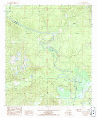
1985 Map of Fishville
USGS Topo · Published 1985About this map
Little River defines the winding boundary between Grant and La Salle Parishes, creating a complex landscape of oxbows and swampy depressions in central Louisiana. The river's serpentine path is marked by distinctive landforms like Big Bend, Alligator Bend, and the detached Fool River. This 1980s landscape shows the intersection of industry and nature, with active Sand & Gravel Pits operating just west of the Kisatchie National Forest boundary. Small settlements and historic river crossings such as Thompson Ferry, Walkers Ferry, and White Sulphur Springs indicate the area's long-standing reliance on the river corridor for transit and community. The terrain rises to the south at Backbone Ridge, overlooking numerous lakes and sloughs including Hardwater Lake and Blue Hole Slough, illustrating the dynamic alluvial environment of the region.
Find a feature on this map
37 named features on this map. Tap any name to fly to it.
Don’t see what you’re looking for? This feature index may not catch every label — zoom into the map to look around manually.
Map Details
Editions of this 1985 Fishville Map
This is the sole edition of this map. No revisions or reprints were ever made.
Other maps of this area

1936 · Pollock
USGS Topo · 1:62,500

1941 · Jena
USGS Topo · 1:62,500

1941 · Alexandria
USGS Topo · 1:62,500

1941 · Buckeye
USGS Topo · 1:62,500

1941 · Pollock
USGS Topo · 1:62,500

1953 · Alexandria
USGS Topo · 1:250,000

1955 · Alexandria
USGS Topo · 1:250,000

1957 · Alexandria
USGS Topo · 1:62,500

1958 · Pollock
USGS Topo · 1:62,500

1958 · Jena
USGS Topo · 1:62,500