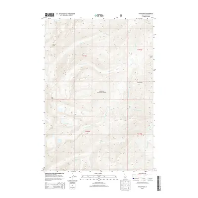
2013 Map of Fitsum Peak
USGS Topo · Published 2013About this map
Buckhorn Hot Spring sits near the confluence of Buckhorn Cr and its southern forks, marking a geothermal landmark within the high elevations of the Payette National Forest. This 2013 survey of Valley County illustrates a landscape defined by sharp divides and a complex drainage system where the Fitsum Cr and Buckhorn basins dominate the geography. Significant peaks, including Fitsum Peak and Nick Peak, provide anchors for the surrounding ridges such as Sixmile Ridge. The map details a network of alpine water bodies like Buckhorn Lake and Rainbow Lakes, which feed the various creek forks. The cartography reveals a wilderness area with limited road access, emphasizing the natural hydrology of the Salmon River Mountains, from the headwaters of Idler Cr to the eastern reach of Homedale Cr.
Find a feature on this map
24 named features on this map. Tap any name to fly to it.
Don’t see what you’re looking for? This feature index may not catch every label — zoom into the map to look around manually.
Map Details
Editions of this 2013 Fitsum Peak Map
This is the sole edition of this map. No revisions or reprints were ever made.
Other maps of this area

1956 · Elk City
USGS Topo · 1:250,000

1957 · Challis
USGS Topo · 1:250,000

1960 · Elk City
USGS Topo · 1:250,000

1960 · Challis
USGS Topo · 1:250,000

1963 · Challis
USGS Topo · 1:250,000

1969 · Enos Lake
USGS Topo · 1:24,000
1969 · Box Lake
USGS Topo · 1:24,000

1969 · Williams Peak
USGS Topo · 1:24,000

1973 · Blackmare
USGS Topo · 1:24,000

1973 · White Rock Peak
USGS Topo · 1:24,000