
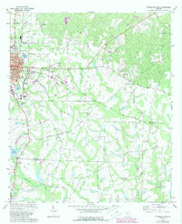
1972 Map of Fitzgerald East
USGS Topo · Published 1976About this map
Fitzgerald's eastern grid and the surrounding agricultural landscape of South Georgia are defined by the convergence of rail and creek systems in the early 1970s. The Seaboard Coast Line railroad cuts diagonally across the terrain, serving as a primary corridor through small communities like Ashton and Pine Level. This area sits at the boundary of Ben Hill and Irwin counties, where the land begins to drain into numerous watercourses including Turkey Creek, Satilla Creek, and Willacoochee Creek. Local heritage is preserved in the high density of small rural burial grounds and sanctuaries, such as Old Field Cem, Mc Cook Cem, and Mt Olive Ch. The map illustrates the town's expansion toward the Fitzgerald Country Club and Lake Beatrice, contrasting the organized municipal streets with the irregular patterns of the outlying swampy lowlands along Brushy Creek.
Find a feature on this map
35 named features on this map. Tap any name to fly to it.
Don’t see what you’re looking for? This feature index may not catch every label — zoom into the map to look around manually.
Map Details
Editions of this 1972 Fitzgerald East Map
2 editions found
Other maps of this area

1953 · Waycross
USGS Topo · 1:250,000

1958 · Waycross
USGS Topo · 1:250,000

1972 · Ambrose
USGS Topo · 1:24,000

1972 · China Hill
USGS Topo · 1:24,000

1972 · Ocilla East
USGS Topo · 1:24,000

1972 · Queensland
USGS Topo · 1:24,000

1973 · Ocilla West
USGS Topo · 1:24,000

1973 · Fitzgerald West
USGS Topo · 1:24,000

1977 · Osierfield
USGS Topo · 1:24,000
1977 · Queensland
USGS Topo · 1:24,000