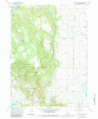
1964 Map of Fitzwater Point
USGS Topo · Published 1984About this map
Fremont National Forest dominates the western half of this landscape, rising to elevations at Fitzwater Point and Fitzwater Pass. The topography transitions from these timbered heights down into the ranching country of the east, where the Drews Creek drainage feeds into a complex network of man-made water systems. The map documents an era of established livestock operations, naming family-held lands such as Friday Ranch, Beeraft Ranch, and Briggs Ranch.
Find a feature on this map
106 named features on this map. Tap any name to fly to it.
Don’t see what you’re looking for? This feature index may not catch every label — zoom into the map to look around manually.
Map Details
Editions of this 1964 Fitzwater Point Map
3 editions found
Other maps of this area

1886 · Alturas
USGS Topo · 1:250,000

1892 · Alturas
USGS Topo · 1:250,000

1954 · Alturas
USGS Topo · 1:250,000

1955 · Klamath Falls
USGS Topo · 1:250,000

1958 · Alturas
USGS Topo · 1:250,000

1958 · Klamath Falls
USGS Topo · 1:250,000

1962 · Alturas
USGS Topo · 1:250,000

1962 · Willow Ranch
USGS Topo · 1:62,500

1962 · South Mountain
USGS Topo · 1:62,500

1964 · Drews Reservoir
USGS Topo · 1:24,000