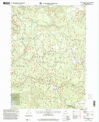
1998 Map of Five Hundred Flat
USGS Topo · Published 2000About this map
Malheur National Forest dominates this landscape in Grant County, characterized by a complex network of seasonal drainages and named springs. During the late 1990s, the area maintained its character as working forest land, marked by several former camp locations including Elkhorn Cow Camp and Cheatem Holler Camp. Significant terrain features like Smoky Mountain and Gilbert Ridge define the local topography, while numerous water sources such as Five Hundred Flat Springs and The Potholes indicate the vital importance of water management in this high-elevation environment. The presence of Lost Cabin and various meadows like Wymer Meadow and Myrtle Park Meadows suggests a history of grazing and transient settlement. Infrastructure is limited to forest roads like the Bear Valley Burns R D, connecting these remote sites to the larger regional ranger districts.
Find a feature on this map
34 named features on this map. Tap any name to fly to it.
Don’t see what you’re looking for? This feature index may not catch every label — zoom into the map to look around manually.
Map Details
Editions of this 1998 Five Hundred Flat Map
This is the sole edition of this map. No revisions or reprints were ever made.
Other maps of this area

1955 · Burns
USGS Topo · 1:250,000

1955 · Canyon City
USGS Topo · 1:250,000

1958 · Burns
USGS Topo · 1:250,000

1959 · Burns
USGS Topo · 1:250,000

1959 · Canyon City
USGS Topo · 1:250,000

1959 · West Myrtle Butte
USGS Topo · 1:62,500

1959 · Sawtooth Creek
USGS Topo · 1:62,500

1961 · Logdell
USGS Topo · 1:62,500

1961 · Izee
USGS Topo · 1:62,500

1981 · Dayville
USGS Topo · 1:100,000