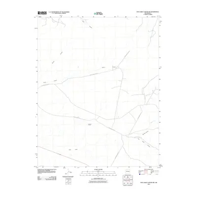
2010 Map of Five Lakes Canyon NW
USGS Topo · Published 2010About this map
Cañon Largo and the drainage network of the high desert define this 2010 survey of Sandoval County. The landscape is marked by a complex system of dry washes and deep incisions, including Burro Canyon, Bonita Canyon, and the sprawling Five Lakes Canyon. Human infrastructure in this arid environment is limited to vital water points and a specialized road network. The Twin Tanks Windmill stands as a lonely landmark of ranching or local survival in the central part of the quadrangle. Transport is dominated by indigenous agency thoroughfares, specifically Indian Service Route 20 and Indian Service Rte 22, which trace the higher ground between basins like Chacon Canyon and Menfee Canyon. This map provides a clear record of modern tribal land access and the persistence of remote landmarks in the American Southwest.
Find a feature on this map
12 named features on this map. Tap any name to fly to it.
Don’t see what you’re looking for? This feature index may not catch every label — zoom into the map to look around manually.
Map Details
Editions of this 2010 Five Lakes Canyon NW Map
This is the sole edition of this map. No revisions or reprints were ever made.
Other maps of this area

1889 · Largo
USGS Topo · 1:250,000

1895 · Largo
USGS Topo · 1:250,000

1954 · Aztec
USGS Topo · 1:250,000

1958 · Aztec
USGS Topo · 1:250,000

1962 · Aztec
USGS Topo · 1:250,000

1963 · Otero Store
USGS Topo · 1:24,000

1963 · Lindrith
USGS Topo · 1:24,000
1963 · Arroyo Chijuillita
USGS Topo · 1:24,000
1963 · Billy Rice Canyon
USGS Topo · 1:24,000
1963 · Taylor Ranch
USGS Topo · 1:24,000