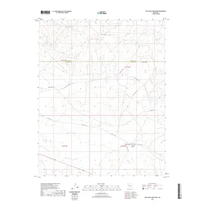
2020 Map of Five Lakes Canyon NW
USGS Topo · Published 2020About this map
Five Lakes Canyon and Cañon Largo converge in this high-desert landscape on the border of Sandoval and Rio Arriba counties. The terrain is defined by a series of deep drainages, including Burro Canyon, Bonita Canyon, and Menfee Canyon, which carve through the sandstone plateau. A network of Bureau of Indian Affairs routes, such as Indian Svc Rte 20 and Indian Svc Rte 22, provides the primary access through this sparsely populated region. Evidence of the challenging environment is clear from map notes warning of sandy roads and sections requiring four-wheel drive, particularly near the intersections with Indian Svc Rte 38. This modern survey records the persistent drainage patterns of the Arroyo Valles and the intricate topography of the San Juan Basin as they appeared in the early 21st century.
Find a feature on this map
17 named features on this map. Tap any name to fly to it.
Don’t see what you’re looking for? This feature index may not catch every label — zoom into the map to look around manually.
Map Details
Editions of this 2020 Five Lakes Canyon NW Map
This is the sole edition of this map. No revisions or reprints were ever made.
Other maps of this area

1889 · Largo
USGS Topo · 1:250,000

1895 · Largo
USGS Topo · 1:250,000

1954 · Aztec
USGS Topo · 1:250,000

1958 · Aztec
USGS Topo · 1:250,000

1962 · Aztec
USGS Topo · 1:250,000

1963 · Otero Store
USGS Topo · 1:24,000

1963 · Lindrith
USGS Topo · 1:24,000
1963 · Arroyo Chijuillita
USGS Topo · 1:24,000
1963 · Billy Rice Canyon
USGS Topo · 1:24,000
1963 · Taylor Ranch
USGS Topo · 1:24,000