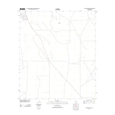
2012 Map of Fivemile Mesa
USGS Topo · Published 2012About this map
Fivemile Mesa dominates this Pecos County landscape, providing a high-elevation landmark in a region defined by its arid, open stretches. This 2012 survey by the U.S. Geological Survey illustrates the intersection of vast, undeveloped terrain with recent residential or agricultural layout. A specific cluster of avian-named roads, including Cardinal St, Bluebird St, and Wren St, appears in the northwest, often representing ranching divisions or emerging rural subdivisions. The presence of Gonzales Loop further indicates the transition toward established family or property access points. These local labels suggest a quiet, structured development pattern amidst the expansive cattle country of West Texas, where road networks are often sparse but purposefully named to denote specific land parcels or communities.
Find a feature on this map
8 named features on this map. Tap any name to fly to it.
Don’t see what you’re looking for? This feature index may not catch every label — zoom into the map to look around manually.
Map Details
Editions of this 2012 Fivemile Mesa Map
This is the sole edition of this map. No revisions or reprints were ever made.
Other maps of this area

1921 · Fort Stockton
USGS Topo · 1:62,500

1923 · Fort Stockton
USGS Topo · 1:62,500

1923 · Sierra Madera
USGS Topo · 1:62,500

1928 · Comanche Spring
USGS Topo · 1:125,000

1954 · Fort Stockton
USGS Topo · 1:250,000

1958 · Fort Stockton
USGS Topo · 1:250,000

1970 · Fort Stockton West
USGS Topo · 1:24,000

1970 · Twelvemile Mesa
USGS Topo · 1:24,000

1970 · East Mesa
USGS Topo · 1:24,000
1970 · East Mesa SW
USGS Topo · 1:24,000