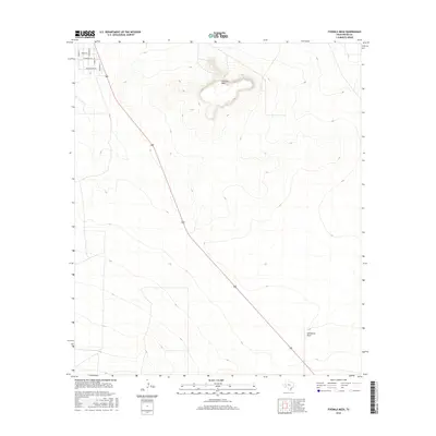
2016 Map of Fivemile Mesa
USGS Topo · Published 2016About this map
Fivemile Mesa rises as a prominent landmark in this desert landscape of Pecos County, situated above the drainage of Sixshooter Draw. The terrain is characterized by broad contours and the stark transition between the elevated mesa and the surrounding flats. In the northwestern corner, a small residential cluster introduces a suburban grid into the wide-open space, with street names inspired by local birdlife including Cardinal St, Oriole Ln, and Mockingbird Ln. This 2016 survey shows how modern infrastructure, represented by the straight corridor of Highway 285, bisects the arid environment, connecting the isolated residential pocket with the larger regional network while navigating the natural topography of the Trans-Pecos region.
Find a feature on this map
10 named features on this map. Tap any name to fly to it.
Don’t see what you’re looking for? This feature index may not catch every label — zoom into the map to look around manually.
Map Details
Editions of this 2016 Fivemile Mesa Map
This is the sole edition of this map. No revisions or reprints were ever made.
Other maps of this area

1921 · Fort Stockton
USGS Topo · 1:62,500

1923 · Fort Stockton
USGS Topo · 1:62,500

1923 · Sierra Madera
USGS Topo · 1:62,500

1928 · Comanche Spring
USGS Topo · 1:125,000

1954 · Fort Stockton
USGS Topo · 1:250,000

1958 · Fort Stockton
USGS Topo · 1:250,000

1970 · Fort Stockton West
USGS Topo · 1:24,000

1970 · Twelvemile Mesa
USGS Topo · 1:24,000

1970 · East Mesa
USGS Topo · 1:24,000
1970 · East Mesa SW
USGS Topo · 1:24,000