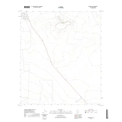
2019 Map of Fivemile Mesa
USGS Topo · Published 2019About this map
Fivemile Mesa rises prominently above the West Texas landscape, a distinct landform that anchors this section of Pecos County. The plateau dominates the northern half of the area, its contours defining the local topography as the land slopes toward Sixshooter Draw in the southeast. A small residential grid is established in the northwest corner, characterized by streets named for local avian life such as Cardinal St, Robin St, and Hummingbird Ln. This 2019 survey by the U.S. Geological Survey illustrates a sparsely populated region where modern ranching or rural development meets traditional topographical features. A major roadway cuts diagonally through the center of the sheet, providing the primary artery for travel through this open terrain. The combination of established street names and ancient landforms reflects the gradual human imprint on this part of the Trans-Pecos region.
Find a feature on this map
11 named features on this map. Tap any name to fly to it.
Don’t see what you’re looking for? This feature index may not catch every label — zoom into the map to look around manually.
Map Details
Editions of this 2019 Fivemile Mesa Map
This is the sole edition of this map. No revisions or reprints were ever made.
Other maps of this area

1921 · Fort Stockton
USGS Topo · 1:62,500

1923 · Fort Stockton
USGS Topo · 1:62,500

1923 · Sierra Madera
USGS Topo · 1:62,500

1928 · Comanche Spring
USGS Topo · 1:125,000

1954 · Fort Stockton
USGS Topo · 1:250,000

1958 · Fort Stockton
USGS Topo · 1:250,000

1970 · Fort Stockton West
USGS Topo · 1:24,000

1970 · Twelvemile Mesa
USGS Topo · 1:24,000

1970 · East Mesa
USGS Topo · 1:24,000
1970 · East Mesa SW
USGS Topo · 1:24,000