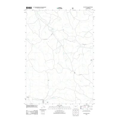
2012 Map of Flag Butte
USGS Topo · Published 2012About this map
Wagonhammer Ranch anchor this landscape of the High Plains, where the terrain is defined by a dense network of seasonal drainages and draws. The map illustrates a ranching and industrial geography, centered on the M-O Oil Field in the southern portion of the quadrangle. Distinctive landforms such as Flag Butte and Flatiron Butte rise above the surrounding plains, serving as prominent landmarks for navigation across the open country.
Find a feature on this map
21 named features on this map. Tap any name to fly to it.
Don’t see what you’re looking for? This feature index may not catch every label — zoom into the map to look around manually.
Map Details
Editions of this 2012 Flag Butte Map
This is the sole edition of this map. No revisions or reprints were ever made.
Other maps of this area

1905 · Devils Tower
USGS Topo · 1:125,000

1918 · Moorcroft
USGS Topo · 1:125,000

1918 · Moorcroft
USGS Topo · 1:62,500

1954 · Gillette
USGS Topo · 1:250,000

1955 · Gillette
USGS Topo · 1:250,000

1957 · Moorcroft
USGS Topo · 1:62,500

1957 · Oshoto
USGS Topo · 1:62,500

1958 · Gillette
USGS Topo · 1:250,000

1962 · Gillette
USGS Topo · 1:250,000
1971 · Rozet NE
USGS Topo · 1:24,000