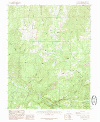
1985 Map of Flanigan Arch
USGS Topo · Published 1985About this map
Dixie National Forest covers the high-elevation terrain of Iron County in the mid-1980s, revealing a landscape defined by deep drainages and prominent peaks. The eastern half of the map is dominated by the massive profile of Summit Mountain and the headwaters of Red Creek. This area serves as a vital watershed, where numerous springs like Bluebell Spring, Eagle Spring, and Grouse Spring feed into complex canyon systems.
Find a feature on this map
49 named features on this map. Tap any name to fly to it.
Don’t see what you’re looking for? This feature index may not catch every label — zoom into the map to look around manually.
Map Details
Editions of this 1985 Flanigan Arch Map
This is the sole edition of this map. No revisions or reprints were ever made.
Other maps of this area

1885 · St. George
USGS Topo · 1:250,000

1886 · Kanab
USGS Topo · 1:250,000

1891 · St. George
USGS Topo · 1:250,000

1950 · Enoch
USGS Topo · 1:24,000

1950 · Cedar City
USGS Topo · 1:24,000

1950 · Enoch
USGS Topo · 1:62,500

1950 · Cedar City
USGS Topo · 1:62,500

1950 · Cedar Mountain
USGS Topo · 1:24,000

1952 · Cedar Mountain
USGS Topo · 1:24,000

1953 · Cedar City
USGS Topo · 1:250,000