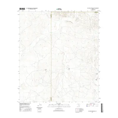
2016 Map of Flat Rock Creek SW
USGS Topo · Published 2016About this map
The boundary between Val Verde and Kinney counties defines the center of this 2016 survey, a region characterized by dramatic elevation changes and dry drainage patterns. The topography is dominated by deep seasonal watercourses such as Javelina Draw and Maurice Canyon, which reveal the erosive forces at work in the Texas ranch lands. Transportation in this area relies on isolated state routes like RM 2523 and RM 3008 N, providing access to the expansive terrain. The presence of Horn Ranch Airport and the Lewis-Private Airport highlights the importance of private aviation for navigating and managing these large, remote landholdings where roads are sparse and the terrain is carved by the winding paths of Sycamore Creek and Cow Creek.
Find a feature on this map
12 named features on this map. Tap any name to fly to it.
Don’t see what you’re looking for? This feature index may not catch every label — zoom into the map to look around manually.
Map Details
Editions of this 2016 Flat Rock Creek SW Map
This is the sole edition of this map. No revisions or reprints were ever made.
Other maps of this area

1941 · Standart
USGS Topo · 1:62,500

1943 · Standart
USGS Topo · 1:62,500

1943 · Del Rio
USGS Topo · 1:62,500

1944 · Flat Rock
USGS Topo · 1:62,500

1944 · Devils Lake
USGS Topo · 1:62,500

1958 · Del Rio
USGS Topo · 1:250,000

1964 · Del Rio
USGS Topo · 1:250,000

1972 · Miers Ranch
USGS Topo · 1:24,000

1972 · Rough Canyon SE
USGS Topo · 1:24,000
1972 · Del Rio NE
USGS Topo · 1:24,000