
1967 Map of Flat Rock Draw SE
USGS Topo · Published 1969About this map
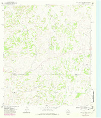
Flat Rock Draw cuts a prominent path through this 1960s cattle and sheep ranching landscape on the boundary of the Edwards Plateau. The map reveals a land divided by large family-owned ranching operations, including the Adah Cauthorn Ranch, Glasscock Ranch, and Johnson Ranch, each marked with complex networks of unimproved roads and fence lines. This era was defined by a transition in land use, where traditional water sources like Miers Well and the seasonal flows of Buckley Draw were joined by industrial markers like an cross-country Pipeline and multiple Gravel Pits. The border between Sutton and Val Verde Counties bisects the lower third of the sheet, illustrating how these expansive holdings spanned political lines in the search for grazing land and water access along the upper reaches of the Devils R.
Find a feature on this map
17 named features on this map. Tap any name to fly to it.
Don’t see what you’re looking for? This feature index may not catch every label — zoom into the map to look around manually.
Map Details
Editions of this 1967 Flat Rock Draw SE Map
2 editions found
Other maps of this area

1954 · Sonora
USGS Topo · 1:250,000

1958 · Sonora
USGS Topo · 1:250,000

1967 · Dunbar Draw SW
USGS Topo · 1:24,000

1967 · Dunbar Draw NW
USGS Topo · 1:24,000

1967 · Flat Rock Draw SW
USGS Topo · 1:24,000

1967 · Shafter Draw
USGS Topo · 1:24,000

1967 · Hudspeth Draw
USGS Topo · 1:24,000

1973 · Turney Draw NW
USGS Topo · 1:24,000

1973 · White Draw NW
USGS Topo · 1:24,000
1973 · White Draw NE
USGS Topo · 1:24,000