
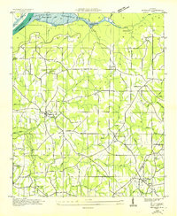
1936 Map of Flat Rock
USGS Topo · Published 1936About this map
Sand Mountain dominates this portion of the Alabama landscape, characterized by a series of deep gulfs and high overlooks during the mid-1930s. The Tennessee Valley Authority and U.S. Geological Survey collaborated to document this area, capturing a rural network of ridge-top settlements and creek-side cemeteries. Small community centers like Flat Rock and Cameronsville serve as focal points for the surrounding farmstead roads. Local spiritual life is well-represented by numerous landmarks including Liberty Hill Ch, Union Ch, and Beulah Chapel. The terrain is deeply incised by water features such as Long Creek and Indian Creek, which cut through the plateaus and create notable geographic markers like Hollaway Point and O'Neal Point. This survey provides a clear view of the Jackson and De Kalb County boundary line as it follows the high ground before the era of widespread modern development.
Find a feature on this map
57 named features on this map. Tap any name to fly to it.
Don’t see what you’re looking for? This feature index may not catch every label — zoom into the map to look around manually.
Map Details
Editions of this 1936 Flat Rock Map
This is the sole edition of this map. No revisions or reprints were ever made.
Other maps of this area

1886 · Stevenson
USGS Topo · 1:125,000

1892 · Stevenson
USGS Topo · 1:125,000

1895 · Stevenson
USGS Topo · 1:125,000

1936 · Trenton
USGS Topo · 1:24,000

1936 · Ider
USGS Topo · 1:24,000

1936 · Shellmound
USGS Topo · 1:24,000

1936 · Bridgeport
USGS Topo · 1:24,000

1936 · Sulphur Springs
USGS Topo · 1:24,000

1936 · Stevenson
USGS Topo · 1:24,000
1936 · Henagar
USGS Topo · 1:24,000