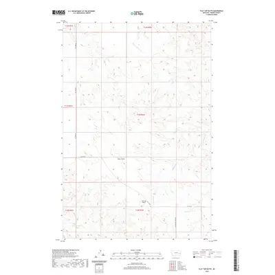
2020 Map of Flat Top Butte
USGS Topo · Published 2020About this map
Flat Top Butte stands as the central topographic landmark in this section of Prairie County, where the high plains are carved by an intricate network of seasonal drainages. The landscape is defined by the headwaters and winding paths of Ash Cr, Newman Hollow Cr, and Dunwoodie Cr, illustrating the erosional patterns typical of the eastern Montana badlands. Remote section lines and gravel paths like Ash Creek Rd and Flat Top Rd provide the primary access through these townships, tracing the natural contours of the land rather than following a rigid grid. The map also documents the drainage of Conns Coulee and Tenmile Cr, which serve as vital water sources for the cattle ranching operations that have historically dominated this region. This modern survey reflects the enduring character of the Big Sky country, where geography dictates the sparse human footprint.
Find a feature on this map
16 named features on this map. Tap any name to fly to it.
Don’t see what you’re looking for? This feature index may not catch every label — zoom into the map to look around manually.
Map Details
Editions of this 2020 Flat Top Butte Map
This is the sole edition of this map. No revisions or reprints were ever made.
Other maps of this area

1953 · Miles City
USGS Topo · 1:250,000

1957 · Miles City
USGS Topo · 1:250,000

1958 · Miles City
USGS Topo · 1:250,000

1966 · Fallon
USGS Topo · 1:24,000

1969 · Little Whitney Creek
USGS Topo · 1:24,000

1969 · Spring Draw
USGS Topo · 1:24,000

1969 · Zero NE
USGS Topo · 1:24,000

1969 · Flat Top Butte SW
USGS Topo · 1:24,000

1969 · Flat Top Butte
USGS Topo · 1:24,000

1969 · Flat Top Butte NE
USGS Topo · 1:24,000