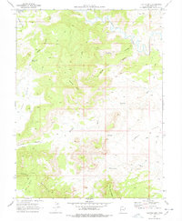
1969 Map of Flattop Mtn
USGS Topo · Published 1978About this map
The Price River carves a winding path through this corner of Emery County, defining a landscape dominated by the prominent elevation of Flattop Mtn. Photographed in 1968, the terrain is marked by a network of drainage systems including Sulphur Gulch and Humbug Canyon, which feed into the primary river valley. Evidence of seasonal water sources and early land use is found at Dripping Spring and Lucky Flats Spring, while a lone Grave and a Corral near the river signify the sparse human presence in this high-desert environment. Navigation across the high plateaus like Cedar Mountain and Huff Bench relied heavily on a system of unnamed Jeep Trails, which connected remote landmarks such as The Door and the drainage of Never sweat Wash. This survey records a period when resource exploration was active, as indicated by the presence of a Drill Hole in the southeastern portion of the quadrangle.
Find a feature on this map
25 named features on this map. Tap any name to fly to it.
Don’t see what you’re looking for? This feature index may not catch every label — zoom into the map to look around manually.
Map Details
Editions of this 1969 Flattop Mtn Map
2 editions found
Other maps of this area

1886 · Price River
USGS Topo · 1:250,000

1896 · Price River
USGS Topo · 1:250,000

1948 · Woodside
USGS Topo · 1:62,500

1949 · Woodside
USGS Topo · 1:62,500

1950 · Woodside
USGS Topo · 1:62,500

1956 · Price
USGS Topo · 1:250,000

1960 · Price
USGS Topo · 1:250,000

1962 · Price
USGS Topo · 1:250,000
1969 · Dry Mesa
USGS Topo · 1:24,000

1969 · Olsen Reservoir
USGS Topo · 1:24,000