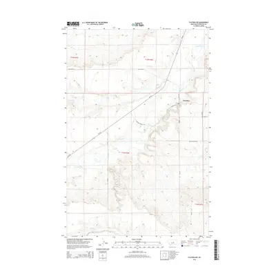
2014 Map of Flatwillow
USGS Topo · Published 2014About this map
Flatwillow stands at the center of this Petroleum County landscape, where the high plains of central Montana meet the winding drainages of the Flatwillow Cr and Pike Cr. This 2014 survey depicts a sparsely populated ranching and agricultural region defined by expansive townships and a network of named access routes such as Pike Creek Rd and Nebraska Feeders Rd. The settlement pattern is anchored by the Flatwillow Cem and the intersection of MT-244 and Golden Eagle Rd, reflecting the enduring footprint of local families in this remote section of the state. To the south, the terrain descends toward Little Wall Cr, showing a topographical character shaped by the gradual erosion of the surrounding plateaus into the creek valleys that have long dictated the placement of roads and homesteads.
Find a feature on this map
17 named features on this map. Tap any name to fly to it.
Don’t see what you’re looking for? This feature index may not catch every label — zoom into the map to look around manually.
Map Details
Editions of this 2014 Flatwillow Map
This is the sole edition of this map. No revisions or reprints were ever made.
Other maps of this area

1954 · Roundup
USGS Topo · 1:250,000

1958 · Roundup
USGS Topo · 1:250,000

1986 · Snoose Creek
USGS Topo · 1:24,000

1986 · Lake Mason NE
USGS Topo · 1:24,000

1986 · Flatwillow
USGS Topo · 1:24,000

1986 · Pike Creek Hills East
USGS Topo · 1:24,000

1986 · Crowley Dam
USGS Topo · 1:24,000

1986 · Big Wall NW
USGS Topo · 1:24,000
1986 · Yellow Water Reservoir
USGS Topo · 1:24,000
1986 · Jim Coulee
USGS Topo · 1:24,000