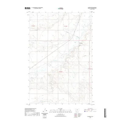
2020 Map of Flatwillow
USGS Topo · Published 2020About this map
Flatwillow is the central point of interest in this Petroleum County landscape, where the high plains of Montana are etched by a series of drainage systems. The small community and nearby Flatwillow Cem sit near the confluence of Flatwillow Cr and Pike Cr, serving as a quiet focal point for the surrounding ranching and agricultural lands. The road network, including Flatwillow Rd and Sharkey Rd, follows the natural contours of the stream valleys, reflecting the historical importance of water access for settlement in this semi-arid region. Further south, the map tracks the upper reaches of Little Wall Cr, showing a terrain defined by subtle shifts in elevation and sparse vegetation. The arrangement of section lines and township boundaries, such as t13n r26e, underscores the systematic land divisions that shaped the development of eastern Montana.
Find a feature on this map
13 named features on this map. Tap any name to fly to it.
Don’t see what you’re looking for? This feature index may not catch every label — zoom into the map to look around manually.
Map Details
Editions of this 2020 Flatwillow Map
This is the sole edition of this map. No revisions or reprints were ever made.
Other maps of this area

1954 · Roundup
USGS Topo · 1:250,000

1958 · Roundup
USGS Topo · 1:250,000

1986 · Snoose Creek
USGS Topo · 1:24,000

1986 · Lake Mason NE
USGS Topo · 1:24,000

1986 · Flatwillow
USGS Topo · 1:24,000

1986 · Pike Creek Hills East
USGS Topo · 1:24,000

1986 · Crowley Dam
USGS Topo · 1:24,000

1986 · Big Wall NW
USGS Topo · 1:24,000
1986 · Yellow Water Reservoir
USGS Topo · 1:24,000
1986 · Jim Coulee
USGS Topo · 1:24,000